While Alabama was divided into two commercial sections by her rivers, the roads which connected her with the rest of the country did not tend to draw these two sections together. There were two main routes of travel connecting Washington with New Orleans: the one which passed through Richmond, Raleigh, Columbia, Milledgeville, and Montgomery to Mobile; and the one which passed into the Valley of Virginia at Rockfish Gap, threaded the Valley and then followed the course of the Holston to Knoxville. From Knoxville, it passed to Huntsville, then on to Tuscumbia at Muscle Shoals, and followed the Natchez Trace to New Orleans. In addition to these, there was one other important route of travel between the East and the Southwest. This was a continuation of the National Highway from Cumberland on the Potomac to Wheeling. Passing from Zanesville, Ohio, to Maysville, Kentucky, it ran on through Lexington and Nashville, joining the Natchez Trace at Muscle Shoals.Most of the travelers journeying from the East to New Orleans took the route through the Southern capitals. Some of them, instead of going all the way to Mobile before embarking, took boat at Montgomery and made the circuitous voyage down the river rather than endure longer the hardships of the road. Hodgson, who passed this way in 1820, took the land route to Mobile but Lafayette took the water course when he came in 1825,3S and so did the Duke of Saxe-Weimar-who followed in 1828.
A journey over the roads of that day was a real undertaking. The traveler had to content himself with log cabin accommodations as he passed through the forests, and the inns of the towns were not attractive. It was a frequent occurrence for vehicles to be upset at some danger to life and limb, and consequently most of the traveling was done on horseback. The building of a road consisted merely in cutting a passage through the woods, the stumps being left several inches above the ground. Bogs were traversed by causeways made of small logs placed close together across the road with dirt thrown on top. Bridges were not ordinarily built across the fordable streams, but ferries were established at the crossings of the rivers.
Instead of going through the Southern capitals, the mail from Washington to New Orleans went through the Valley of Virginia and by Huntsville until 1827. From Huntsville it was carried to Tuscumbia and thence followed the Natchez Trace. As far as Huntsville, there was something that could be called a road, but the Natchez Trace was reported to be nothing more than a broad grass path. The route was circuitous, and in 1816 Congress made an appropriation to enable Andrew Jackson to cut a more direct road from Tennessee to New Orleans. The troops were employed on this work, which was begun in 1817 and completed in 1820. It diverged from the old Trace road at Muscle Shoals, and, passing Columbus, Mississippi, on the Tombigbee River, took a straight course to Madisonville, opposite New Orleans on Lake Ponchartrain.
This Military Road, as it was called, was forty feet wide, had bridges over the smaller streams, and well constructed causeways over the marshy places. But no provisions were made for keeping it in repair, and since the Trace road passed through the towns on the Mississippi while the Military Road lay through a region largely uninhabited, the latter was allowed to fall into disuse. By 1824 the bridges had mostly been washed away and a growth of young trees was flourishing in the road itself. Though it was intended that the mail should have passed this way to New Orleans, it became necessary to cross over below Columbus and continue to take it along the old Trace route.
Though the road to Huntsville was at first a mere branch of the main thoroughfare between Knoxville and Nashville, it afforded a more direct route to New Orleans and this fact was recognized by sending the mail this way after 1822. In 1820 Huntsville was made the terminus of the first stage line in Alabama. This connected with the main line between Knoxville and Nashville, and at first the service was only once a week. This was increased in 1823 to two trips each way every week. In 1825 an increase to three trips a week was made, and the line was extended to Tuscumbia. Stages also connected Tuscumbia with Kentucky and Ohio by the route through Zanesville, Lexington, and Nashville. But below Tuscumbia, the river did not permit of continuous navigation and the Natchez Trace did not permit of stages. Consequently, from Tuscumbia to New Orleans the mails were still carried on horseback.
The route through the Southern capitals, instead of paralleling the streams as did the one through Huntsville, crossed them and hence was more subject to interruption from swollen waters. Though it lay through more populous communities than did the western route, the through mail between Washington and New Orleans was not carried along it until the latter part of 1827. This accounts for the later development of stage facilities on the road between Milledgeville, Montgomery, and Mobile. The first stage route from Montgomery eastward was established in 1821. At first only one trip a week was made, but this was increased in 1823 to two trips weekly. Not until 1826 was there a regular line established between Montgomery and Milledgeville giving three trips weekly. It was during the next year that the through mail to New Orleans began to come this way. It was carried from Montgomery to Mobile in two-horse wagons, from Mobile to Pascagoula by sulkey, and from Pascagoula to New Orleans by steam packet.
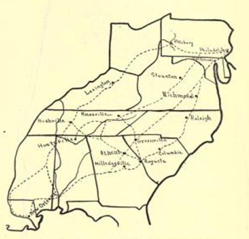
This is as far as the development of transportation through Alabama went during the period under review, but a great deal of futile discussion was aroused by the Congressional act of 1824 which provided for the survey of a system of internal improvements. Calhoun, in his report on the subject, stated that a highway from Washington to New Orleans would be best calculated to further the interests of that section and of the country lying south of the Capitol City and the survey of three separate routes was planned. The first of these was to intersect the eastward-flowing rivers at their fall lines; the second was to lie between this and the Appalachian Mountains; and the third was to pass down the valley beyond the mountains.The surveys were accordingly made. The routes recommended in the first two cases were already followed by lines of travel.
The first one lay through the Southern capitals, passing on to Mobile. The second diverged from this in northern Virginia and passed through the piedmont towns of Petersburg, Salisbury, Greenville, and Athens, rejoining the other route near where it entered Alabama. But the third route differed from that already established. After passing through the valley of Virginia to Knoxville, instead of proceeding to Huntsville, it followed the valley of the Tennessee to where Chattanooga now stands, then, paralleling Lookout Mountain, passed into the valley of the Cahawba.
From Centreville, at the falls of the Cahawba, it turned westward and passed out of the State by way of Demopolis. This route followed the course of the rivers and valleys, and, theoretically, was perhaps the best. But it had the disadvantage of Jackson's Military Road in that it did not follow an established route of travel. The Huntsville people proclaimed loudly that the route through their town should be surveyed, and they had their way. The mail then took this course to New Orleans, and the Postmaster General favored the route. After the survey was made, no further action was ever taken. The Old South stood opposed to the policy of internal improvements, and, shortly, with Jackson's aid, it was able to restrain the desires of those who would have the general Government construct a system of communication for the country.
Commercially distant as were the two sections of Alabama, there was necessarily some communication between them. The first route traveled from north to south seems to have been the portage between the Muscle Shoals and the head of navigation on the Tombigbee at Cotton Gin Port. Pioneers floating down the Tennessee took this trail in order to reach the settlements in the neighborhood of St. Stephens.
Jackson, in the Creek War, cut a road from Huntsville southward throughthe country east of the Coosa River and on to the place where Fort Jackson was established at the confluence of the Coosa with the Tallapoosa. By this route travelers were enabled to reach the Federal Road in the neighborhood of Montgomery. Yet there was but one passage between north and south Alabama which came to be traveled with frequency, and that was the one which led from Huntsville through Jones Valley to Tuscaloosa at the head of navigation on the Black Warrior. The road through the Valley was good, and much produce came down from Tennessee and reached central and southern Alabama by this way.
Alabama
Alaska
Arizona
Arkansas
California
Colorado
Connecticut
Delaware
Florida
Georgia
Hawaii
Idaho
Illinois
Indiana
Iowa
Kansas
Kentucky
Louisiana
Maine
Maryland
Massachusetts
Michigan
Minnesota
Mississippi
Missouri
Montana
Nebraska
Nevada
New
Hampshire
New
Jersey
New
Mexico
New York
North
Carolina
North
Dakota
Ohio
Oklahoma
Oregon
Pennsylvania
Rhode
Island
South
Carolina
South
Dakota
Tennessee
Texas
Utah
Vermont
Virginia
Washington
West
Virginia
Wisconsin
Wyoming
Washington
D.C.
Home